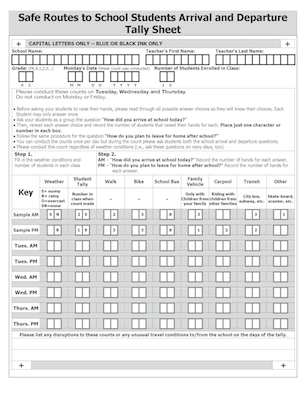
 Student tallies are a key part of the Safe Routes to School Program. The tallies record how students get to and from school on three days of one week. The categories are walking, bicycling, other (meaning other active transportation modes such as skateboarding and scootering), family vehicle, carpool, transit, and school bus. Classroom teachers explain the categories to their students and then record the modes by a raise of hands, six times during the sampling week.
The data becomes part of the national Safe Routes to School Data System, which keeps a permanent record of student tallies (and parent surveys) completed in our district and all over the country. The data is also used by the district and by transportation agencies (Sacramento County and City of Citrus Heights) to plan projects and design procedures that will have the most impact on the greatest number of students.
The data is also a critical part of all transportation-related grant applications. The competition for funds is so great that only locations with good data are awarded grants. Of course there is a lot more to a successful grant application than just the student mode share information, but it is a key element. For example, two grants recently received by the City of Citrus Heights for school-related projects, Mariposa Sidewalks Phase 4 and the Electric Greenway, depending upon the district already having mode share data for the affected schools. Fortunately, due to the Citrus Heights School Walkability Project, we had data for all but one of the schools, and that school did the tally for the grant application.
We encourage every school in the district to complete the student tally every fall. Schools that are part of our current Safe Routes to School ATP grant must complete the survey once per year.
Every school can make the student tally data part of their safety plan (Comprehensive School Safety Plan template), as safety plans should address the issue of how students get to and from school, and how students walking and bicycling interact with drivers dropping off and picking up other students (“procedures for safe ingress and egress of pupils, parents, and employees from school site” – California Education Code; and “Traffic directions for pick-up and drop-off visible to make parking lot traffic flow efficient as possible.” – San Juan administrative regulation).
The assessments page has links to historical student tally data for all schools that have participated in the past. Mode share data is also a basic piece of information that the Safe Routes to School Program uses when schools request special assistance to deal with traffic or safety issues that have either grown worse of time or are new.
For more information about participating in the tally, contact Dan Allison, Safe Routes to School Coordinator, dan.allison@sanjuan.edu.

